Současné změny sociálního prostředí v českých suburbiích
Projekt se věnuje současným změnám sociálního prostředí v zázemí českých měst. Nejprve řeší vymezení rozsahu suburbanizace v českém systému osídlení a proměny sociální, demografické a etnické struktury obyvatelstva suburbií v posledních patnácti letech. Analýza založená na statistické evidenci migrace se věnuje zejména ověření hypotéz o (i) narůstající etnické heterogenizaci suburbií; a (ii) návratu obyvatel suburbií zpět do jádrových měst (reurbanizaci).
Autoři specializovaných map děkují Grantové agentuře České republiky za podporu v rámci projektu č. 18-14510S.
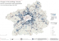
The aim of this map is to measure the density of buildings in the territory of Central Bohemia and analyze its change during the period 2010–2018 by arguing its possible connections with the population concentration and the location of transport infrastructure. This will contribute to understanding where the construction and development that has been happening during this period. To realize this map of density study, we used the Kernel Density (KD) tool available on ArcMap 10.6 Spatial Analyst toolbox.
KUKELI, G., NEMEŠKAL, J. (2019): Changes in the buildings´ density and its connection with population in the Central Bohemia Region 2010-2018. Specializovaná mapa. Přírodovědecká fakulta, Univerzita Karlova.
Kartografické zpracování: Nemeškal Jiří